| Top > National survey on the natural environment > Marine Organisms Survey/Marine Organisms Biological Environment Survey (3rd Survey) |
| Marine Organisms Survey/Marine Organisms Biological Environment Survey (3rd Survey) | ||
| Survey Sequence and Effective Years (All years are fiscal years) |
data | Result list (Japanese only except |
| 2nd survey 1978 |
The National Survey on the Marine Natural Environment Report of Marine Organisms The National Survey on the Marine Natural Environment Report of Marine Organisms (Details of the Plot, Vertical distributions) |
|
| 3rd survey 1984-1986 |
Report of the Marine Organisms Biological Environment Survey Report of the Marine Organisms Biological Environment Survey -Attached Data- |
|
| 4th survey 1989-1992 |
Outline of Survey on Marine Organisms Environment (Coral Reef) |
|
|
|
|
|
|
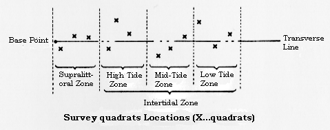
| To monitor the conditions and environments of marine organisms in Japan on a continuing basis, this survey investigated organisms living along the supralittoral zone (splash zone) and intertidal zone. | |
|
|
| 107 places in all 39 prefectures having seacoasts
were surveyed (94 places in the 2nd survey).
Twice a year at each location, in spring
(usually May) and summer (usually September),
a site survey was done at low tide of the
spring tide. The survey set up three quadrats, in each of the supralittoral, high tide, mid-tide and low tide zones, arrayed as if along a line at right angles to the waterline drawn from the survey base situated at the upper limit of tidal flow. Organisms in the quadrats were collected and analyzed. |
|
|
|
| (1) Horizontal distribution A map was drawn showing the distribution of relatively frequently occurring organisms, those appearing at more than 5 mud and sand beaches and at more than 10 rocky beaches. (2) Species Count No great difference was seen in flora from area to area. For animals, however, mud, sand and rocky beaches in the southern portions of the Japanese Archipelago all had high species counts, while northern portions tended to have low counts. This may reflect differences in sea flow, differences between high and low tides, topography and so forth. |
|
 |
|
|
|
|
| All Rights Reserved, Copyright Ministry of the Environment. | |
 1. Survey Objectives