1.
BIOGEOGRAPHY OF THE WORLD
動物地理区や植物区系は、世界各地に分布する動物や植物を比較して、それぞれの特徴をもった地域に区分したものである。
生物の分布には、大きく分けて、生態的分布と地理的分布の2つの要因がある。前者は、その生物自身のもつ環境への適応力によって分布域の定まるものであり、後者は、移動をはばむ地理上の障害によって分布が制限されるものである。したがって、生物の分布を考える場合は、本来は種ごとにその由来を分析しなければならない。
しかし、より大きな分類単位で生物をとりあげてみると、その中のそれぞれの種に共通する分布域があらわれ、いくつかに区分できる。これは、種ごとの生活型の類似や、地史と深く関係した系統上の近縁性によるものである。
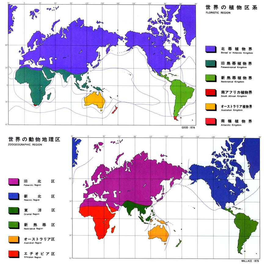
動物全体についてみると、図のような6区にまとめるのが一般的である。注目する動物群によって、いくつかの区分けができるが、図の区分けは比較的多くの動物群に適用できるものである。同様に、植物全体についてみると、世界は6つの植物界に区分できる。その区分は、動物よりも強く緯度に関係しているのがわかる。
生物は進化しており、また地史的な単位でみれば地形や気候も変化している。現在の分布域は、そのような動的な歴史の一断面である。
Biogeographical regions are the divisions of the world according to the characteristic fauna and flora.
The distribution of plants and animals depends on two main factors: ecological and geographical. The former is their adaptability to the environment and the latter is the geographical barriers limiting their distribution. Hence, when studying the reasons for distribution, the analysis should be done, theoretically, species by species.
However, when handling larger taxonomic units, distribution areas common to all species belonging to the unit are recognized and division into regions becomes possible. The division is based on the resemblance of life forms of species and their systematic closeness, which is related to geological history.
Zoogeographically the world is generally divided into the six regions shown on the map. This division is applicable to a larger number of animal groups, though there are some other ways of division differing according to the group of animals concerned. Similarly, phytogeographically the world is divided into six regions related more closely to latitude than zoogeographical regions.
Plants and animals still continue their evolution, and topography and climate are also changing on a geohistoric scale. Hence, the present biogeographical regions represent a cross section of this dynamic history.