SUMMARY
The survey amounted to a "national census on vegetation," with nationwide checks carried out on the natural environment. It was the first time in the world that such findinings were expressed in numerical terms.
The survey brought out in a clear relief the fact that precious nature has been lost through development in extensive parts of the country.
It revealed, among others, the following points: (1) Nature in 80 perpent of the Japanese archipelago has been touched by man in some form or other, with only 20 percent left in a virgin state of naturalness; (2) Of the 51 major rivers, only four have not undergone physical changes; (3) Of the country's coastlines, 60 percent retain unsullied naturalness, while more than 20 percent have been affected by port construction, land reclamation, and other forms of manmade changes.
A central role in the survey was played by the Natural Environment Preservation Survey Committee , which was set up in 1973 with Prof. Kinji Hogetsu of Tokyo Metropolitan University as its chairman. About 2,000 experts in ecology and agricultural and forestry sciences were mobilized across the country.
The survey was mainly concerned with (1) degrees of naturalness, (2) nature's contribution to the human living environment, and (3) nature of outstanding value. Several unique methods were employed.
For example, 360 typical floras across the country were put down in 1/50,000th scale vegetation maps for respective prefectures, while the same floras were calassified into a scale of 10 grades according to their naturalness. Further, the whole Japanese archipelago was divided into one-kilometer squares, totaling 360,000. Each of these squares was given a rating in the degree of naturalness in vegetation. The ratings thus determined were fed into a computer to project vegetation pictures for the whole country, regional blocs, and respective prefectures.
These ratings are a measure of how much nature remains intact. They also show the extent to which nature has been destroyed by man. The findings on this point constitute a principal feature of the survey. It was the first time that the realities in the destruction of nature, for which there had been no previous scientific data, were depicted in numerical terms.
The Environment Agency plans to carry out a "national census on vegetation" every five years hereafter to follow up on changes in the situation. Data from these surveys are expected to provide important basic reference materials to the review of such governmental plans as the New National Comprehensive Development program (Shinzenso) and the Social Economic Development Program, for working out environmental standards on vegetation, and for environmental impact assessment.
|
1. Degrees of Naturalness
The entire country was divided into three categories - land areas, inlandwater areas (rivers, lakes and marshes), and sea areas (including coastlines). Based on the present conditions regarding floras, living creatures, water quality, and other relevant factors, ratings with the degree of artificiality as the yardstick to show how much nature there is and where.
(1) Land Areas
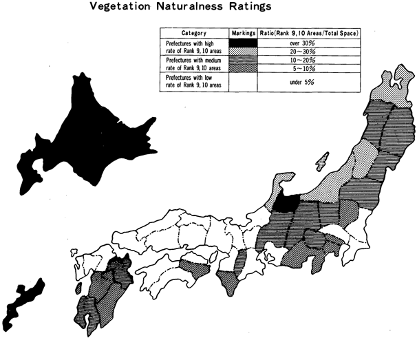
The survey disclosed that Rank 9 and 10 areas in the scale of vegetation -with virgin forests, grassland in a state of naturalness, alpine plants, and the like - accounted for 22.8 percent of the national land space, while Rank 1 areas - urban areas, new housing developments, and the like where there is hardly vegetation-totaled 3.1 percent.
Generally speaking, naturalness ratings were high in Hokkaido, Tohoku, Hokuriku and south Kyushu, whereas development was advanced in the Kanto, Tokai and Kinki districts. Rank 1 areas amounted to 39.7 percent of Tokyo.
(2) Inland-Water Areas
Fifty-one rivers and 67 lakes and marshes across the country were checked for shoreline changes caused by road and housing construction and the like as well as for the quality of water. It was found that four rivers retained naturalness, while nine others had lost it.
(3) Sea Areas
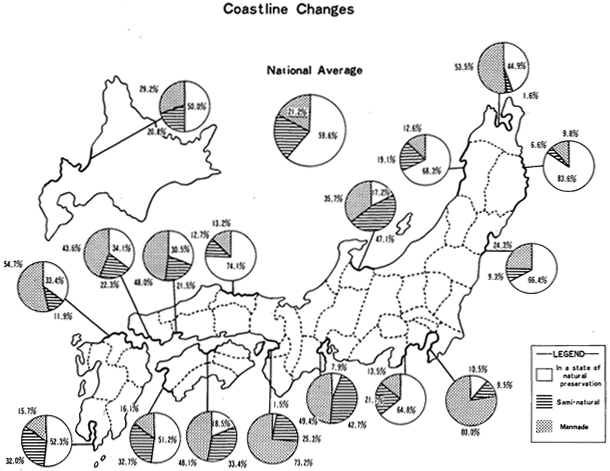
The survey revealed that of the country's coastlines extending a total of 26,500 kilometers, 59.6 percent remained in a virgin state of naturalness. The figure for "half-natural coastlines" - those with roads, shore protection works, and other artificial facilities but retaining naturalness nevertheless -was 19.2 percent. "Artificial coastlines"-those having undergone marked changes because of port construction, reclamation, and other kinds of civil engineering works - tallied 21.2 percent.
2. Nature's Contribution to Human Living Environment
This part of the survey was carried out in a belief that quantitative measurements are needed to learn about the impact of nature on the human living environment. The existing amount of vegetation, vegetation output, and the distribution of birds in the Kanto district were checked. Kanto was chosen because of the marked adulteration of nature caused by human activities in that region.
Estimates on the existing amount of vegetation in the dry weight ・were mainly based on the heights and densities of trees now standing. Vegetation output in the dry weight was figured out from the amount by which trees grow in a year per hectare.
The volume of vegetation existing in the Kanto region was thus put at 126 million tons. The per-capita figure in Tokyo was 0.4 tons as against 18.8 tons in Gumma Prefecture. Areas with less than two tons of vegetation per hectare accounted for 48 percent of Tokyo and 30 percent of Kanagawa Prefecture.
 |
3. Nature of Outstanding Value
Prefectural authorities picked out areas with nature of outstanding academic value in point of singularity, scarcity, historical importance, and other merits. These areas, at 18,000 different locations, were marked out on maps by prefectures.
The survey resulted in some important environmental discoveries. For example, an increase in the population of Japanese antelopes in the Tohoku district was ascertained, and swallows were found to pass the winter around Lake Kasumigaura in Ibaraki Prefecture, though Lake Hamana in Shizuoka Prefecture had earlier been believed to be the northern limit for their wintering.