|
THE NATIONAL SURVEY ON THE NATURAL ENVIRONMENT |
||
|
|
||
|
This survey was conducted in accordance with the Article 5 of the Nature Conservation Law which says: The State should conduct every five years, a basic survey as the basis for policy decisions on conservation of nature; the survey should cover changes in landscape, geology, vegetation, and wildlife. Though it is officially called "The National Survey on the Natural Environment", it is known to the public as the "Green Census" The first survey was carried out in fiscal year 1973, and the results were published in 1974 and 1975 in such forms as "Actual Vegetation Maps", "Maps of Human Disturbance of Vegetation", and "Maps of valuable Natural Environment", all in a scale of l:200,000, and "Report of the Survey for Conservation of Natural Environment: the Green Census" The second survey was conducted in fiscal years 1978 and 1979, and the results were published as "Actual Vegetation Maps, 1:50,000", "Distribution Maps of Plants and Animals, 1:200,000" and detailed reports of the survey on each item were published in national and the prefectural editions. A general report describing the main points of the findings in the survey was also published as "Report of the 2nd Survey of Conservation of Natural Environment: the Green Census". These were published in 1980 and 1981. This book, "The Natural Environment of Japan: an Atlas of the Japanese Natural Environment", is a general summary of the results of the survey and aims to give a comprehensive view of the present state of our natural environment. The framework of the first and second "Green Census" is presented in the following charts. The 1st Natuonal Survey on the Natural Environment |
||
|
|
|
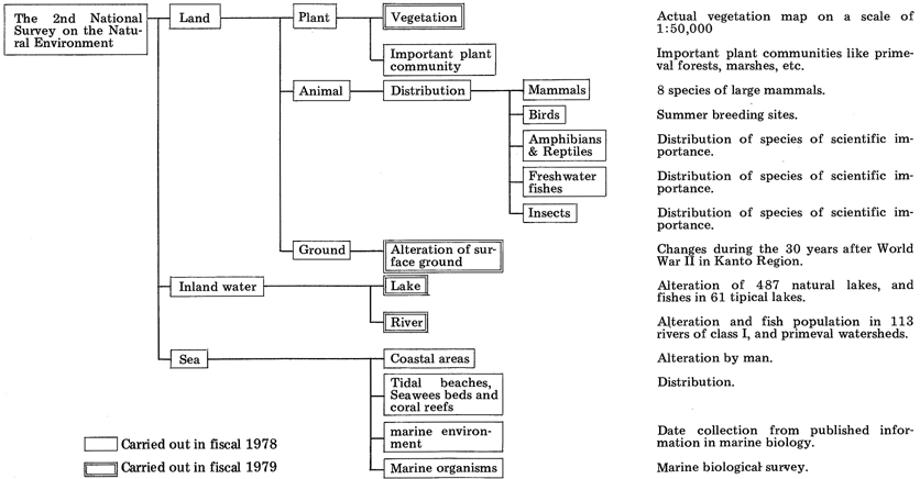
The 2nd Natuonal Survey on the Natural Environment |
|
|
|
1. The Aims and Target of the National Survey 1. The Aims and Target of the Basic Survey The aims of this survey are: (1) to learn the present state of our natural environment, landscape, geology, vegetation, and wildlife, including the habitats of vegetation and wildlife such as land, fresh water, and sea; (2) to study the long-term changes in the natural environment by surveys every five years: (3) to establish a data base regarding the natural environment: (4) to accumulate basic data useful for the planning of conservation measures such as nature conservation areas, natural parks, wildlife protection areas, protected forests, natural monuments, and urban green belts, for environmental asessments, and for developmental planning. However, because a comprehensive survey and analysis of the biological and geographic environment of the whole land area and surrounding sea is very difficult, the following short term targets for about twenty years to come have been set, considering the urgent necessity for policy making and the limited capacity for the survey: (1) Establishment of guidelines for selection and evaluation of important plant and animal species from the viewpoint of preservation, compilation of a list of these plants and animals, and survey of their habitats and populations. (2) Preparation of actual vegetation maps at the scale of 1:50,000 as basic information about the natural environment, revising them every five years. (3) Investigation of the distribution of wildlife occupying large territories and determination of the population size of important animal species. (4) Survey of the natural environment of urban and suburban areas in regard to human amenities. (5) Survey of the alteration of the natural environment of sea coasts, rivers, and lakes by human activities, and preparation of a list of natural areas unaltered by man. (6) Survey of excellent natural landscape and historic and rural landscapes formed by a long history of human activities. (7) Identification of areas important for conservation of nature by systematic organization of this imformation. The data base will be used not only by administrative organizations but also by the general public.
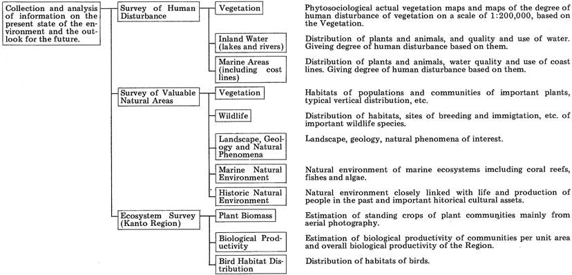
2. Outline of the First National Survey on the Natural Environment The survey consists of three main items: "survey of degree of human disturbance", "survey of valuable natural areas", and "survey on ecosystems". The following are the aims and contents. (1) Degree of Human Disturbance The aim is to know the extent of alteration of nature by man. "Degree of human disturbance" is a measure of the degree of alteration by man of nature. It is judged by surveying separately land, fresh-water (lakes and rivers), and sea (coastal areas). 2. Outline of the First Basic Survey of the Natural Environment The survey consists of three main items: "survey of nature degree", "survey of valuable natural areas", and "survey on ecosystems". The following are the aims and contents. (1) Nature degree The aim is to know the extent of alteration of nature by man. "Nature degree" is a measure of the degree of alteration by man of nature. It is judged by surveying separately land, freshwater (lakes and rivers), and sea (coastal areas). 1 Land vegetation Based on phytosociological actual vegetation maps at a scale of 1:200,000, each area was graded from 1 to 10, 10 being minimum and 1 being maximum human influence. 2 Inland water Freshwater The survey was done separately for lakes and rivers. Sixty-four representative lakes were chosen from the whole country and data were collected of (a) general descriptions, (b) descriptions of watersheds, (c) utilization and alteration of lakeshore, (d) physical and chemical properties of the water, and (e) distribution of organisms in it. About 40 rivers were chosen from the whole country and data were collected of (a) general descriptions of the river, (b) physical and chemical properties of the water, and (c) distribution of organisms in it. 3 Sea From the whole coastal area of every prefecture, data were collected of (a) water quality (transparency and chemical oxygen demand), (b) utilization and alteration of coastal line, and (c) distribution of organisms including shellfish and sea algae, and statistics of fish catches. (2) Valuable natural areas The aim was to identify valuable natural area by the survey of the five items described below, and the criteria for the identification of areas were rarity, endemicity and typicalness. 1 Plants The survey was carried out on individual specimens and on communities. Of the former, the criteria for the selection of objects of the surveys were: (a) species endimic to Japan or to a specific area in it, (b) rare species, (c) northern or southern limit of the species in Japan or in the world, and (d) other important species. For the latter, the criteria were (a) areas containing a variety of communities or showing typical vertical distribution of communities, (b) rarity and intactness, and (c) other important communities. 2 Wildlife Distributions, habitats and breeding sites of selected species of mammals, birds, reptiles, amphibia, freshwater fishes and insects were investigated and their living conditions were studied. The criteria for the selection of species were (a) endemicity to Japan, (b) rarity, (c) southern or northern limit of distribution of species in Japan or in the world, and (d) other important populations. 3 Landscape, geology, and natural phenomena Of the items selected by the Environment Agency, examples were chosen and investigated according to the following criteria: (a) typicalness, (b) rarity, (c) scientific value, and (d) other importance. 4 Marine environment Survey was made of shallow sea less than 20 meters deep and the tidal zone of every prefecture selected according to the following criteria: (a) water not polluted, (b) typical marine ecosystems influenced by the Kuroshio, Tsuhsima, and Chishima Currents and rich in marine organisms like coral reefs, tropical fishes, sea algae and, other organisms of interest, and with variable bottom topography. 5 Historical natural environment Natural landscape associated with historical assets like remains and historical buildings or with life and production in the past are identified. A natural forest associated with some historical asset is an example. (3) Ecosystems The Kanto Region was selected as a specimen of an area with remarkable human activities and with a variety of types of environment. Biomass and biological productivity were estimated to evaluate the contributions of vegetation to the conservation of the human environment.
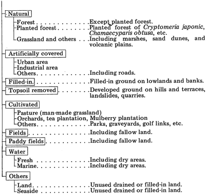
3. Outline of the Second National Survey on the Natural Environment The survey covered land, freshwater, and coastal areas. It was carried out on 10 main items: Designated plant communities, "Animal distribution", "Seashore", "Tidal zone, seaweed bed and coral reef" "Marine environment", and "Biological survey of seashore" were surveyed in 1978, and "Vegetation", "Alteration of surface ground", "Lakes", and "Rivers" were surveyed in 1979. The aims and contents of these items are as follows. (1) Vegetation The vegetation map is an ecological basis not only for the preservation, restoration, and maintenance of nature but also for development for various purposes, and gives indispensable information for all kind of planning. The aim of the survey was to secure detailed information on the present state of vegetation of the country and the preparation of a vegetation map based on investigations in situ and from aerial photographs. Actual vegetation maps at a scale of 1:50,00 covering about one half of Japan were prepared and distributed. (2) Designated plant communities Plant communities of scientific importance or worth preserving were identified by prefectures with the criteria listed below, and their sites and actual state were investigated. The criteria were (a) Primeval or quasi-primeval forests; (b) rare plant communities or populations found in limited places; (c) southern or northern limit of distribution, or isolated distribution of plant communities or populations, even if they were relatively common ones; (d) plant communities or populations specific to particular sites like sand dunes, cliffs, salt marshes, lakes, rivers, moors, alpine zones, and limestone, and having typical features of the communities; (e) plant communities typical to local landscapes; (f) old planted forests left untouched for a long time; (g) plant communities or populations endangered by human activities within a prefecture; (h) other plant communities or populations of scientific importance. (3) Distribution of Animals The distribution of selected mammals, birds, reptiles, amphibians, freshwater fishes and insects was investigated. The contents of the survey are as follows: 1 Mammals The objects of the survey were 8 species of large and medium-sized mammals: Macaca fuscata, Cervus nippon, Selenarctos thibetanus, Ursus arctos, Sus scrofa, Vulpes vulpes, Nyctereutes procyonoides, Meles meles. The whole country was divided into grids ca. 4.5 km x collected from each two persons at two points in each grid. 2 Birds The distribution in the breeding season of ca. 250 species of birds known to breed in Japan was investigated. Observation was made at 2,225 sites and information on breeding was collected at 1,100 sites, with the cooperation of Wildbird Society of Japan. 3 Reptiles and amphibians The distribution and population of species of scientific importance or endangered were investgated. The species are listed below; Reptiles: Cuora flavomarginata, Geoemyda spengleri japonica, Gekko tawaensis, Eublepharis kuroiwae kuroiwae, Eublepharis, Kuroiwae orientalis, Eublepharis kuroiwae splendens, Caretta caretta, Chelonia mydas, Eremochelys imbricata, and Laticaudo semifasciata. Amphibians: Rana brevipoda brevipoda, Rana namiyei, Rana ishikawae, Babina subaspera, Babina holsti, Rhacophorus arboreus, Tylototriton andersoni, Andrias japonicus, Salamandrella keyserlingi. Hynobius nebulosus nebulosus, Hynobius nebulosus tokyoensis, Hynobius tsuensis, Hynobius dunni, Hynobius lichenatus, Hynobius nigrescens nigrescens, Hynobius nigrescens sadoensis, Hynobius retardatus, Hynobius abei, Hynobius naevius, Hynobius okiensis, Hynobius kimurae, Hynobius stejnegeri, Pachypalaminus boulengeri, and Onchodactlus japonicus. 4 Freshwater fishes The distribution and population of species of scientific importance or endangered were investigated. The species are listed below: Hucho perryi, Salvelinus malma, Salveninus imbrius, Hypomesus olidus, Neosalanx regnai, Salanx ariakensis, Tribonodon sp., Aphyocypris chinensis, Acheilognathus longipinnis, Rhodeus ocellatus smithi, Rhodeus atremius, Rodeus suigensis, Tanakia tanago, Pseudoperilampus typus, Cobitis takatusensis, Leptobotia curta; Coreobagrus ichikawai, Gasterosteus aculeatus aculeatus, Gasterosteus aculeatus microcephalus, Pungitius sinensis, Pungtitus sp., Pungitius pungittus, Pungitius tymensis, Coreoperca kawamebari, Trachidermus fasciatus, Cottus kazida, and Hypseleotris bipartita. 5 Insects The distribution and population of species endangered or of scientific importance were investigated. The nationwide distribution of the 10 indicator species listed below and species designated by prefectures with the following criteria were objects of the investigations. Indicator species: Epiophlebia superstes, Tanypteryx pryeri, Nannophya pygmaea, Grylloblattidae. Lethocerus deyrollei. Terpnosia vacua, Luehdorfia japonica, Luehdorfia puzioloi, Sasakia charonda, and Luciola cruciata. Criteria for selection of the designated insects: A. Distribution limited to one place only in Japan. Example: Orthetrum poecilops miyajimensis in Miyajima, Hiroshima; Aeschna subarctica in Kushiro, Hokkaido; and Pyrgus malvae in Mt. Apoi, Hokkaido. B. Distribution limited to a few places in Japan. Example: Colias palaeno and Panchala ganesa loomisi. C. Relatively common species at the northern or southern limit of distribution. Example: Papilio memnon thunbergii in Hiroshima Pref. and Melanitis phedima oitensis in Hiroshima Pref. D. Species endangered in an area. E. Species believed to be extinct in an area. F. Species being reduced in numbers by commercial or non-commercial collection in an area. G. Species suitable for indicators of environment. (4) Alteration of surface ground This survey aimed to learn the quantitative changes in conditions of the surface ground in the Kanto Region (except islands) by comparing the state of surface ground at around 1945, 1960, and 1975. Standard grids of ca. 1km x 1km were classified into the groups listed below mainly on the basis of aerial photographs.
CLASSIFICATION OF SURFACE GROUND |
|
|
|
(5) Lakes With the purpose of watching the progress of deterioration and planning conservation of natural lakes, the transparency of water, which is a general index of water quality and is important for recreational values, and alteration by man were surveyed in addition to general descriptions of 487 natural lakes. The fish fauna was surveyed in 61 typical lakes. (6) Rivers To learn the present state of conservation and utilization of rivers, fish populations and alteration were investigated in 112 rivers of Class I together with the main stream of the Urauchigawa River in Okinawa. Because there remain few rivers with watersheds in primeval conditions (primeval watersheds), it is urgent to take immediate measures for conservation, and watersheds larger than 1,000 ha were investigated. (7) Seaside Alteration by man of coast lines and land areas along the coasts was examined. (8) Tidal beaches, Seaweed beds and coral reefs The distribution, size, type, and environment were investigated. The size, time and reason of disappearance, and present utilization of tidal beaches which disappeared after 1945 and seaweed beds and coral reefs which had disappeared since 1973 were recorded. (9) Marine environment Alteration of the environment of coastal areas was examined. Of 91 selected marine areas, plankton, benthos, periphyton, and occurrences of coliform bacteria and red tide were investigated. (10) Marine biological survey To prepare monitoring of environment and marine organisms in coastal areas at intervals of 5 years, living organisms in tidal zones and splash zones were investigated. |