|
Top > National survey on the natural environment > Grid Square System |
National Survey on the Natural Environment
uses the Grid Square System (3rd grid)
To compile and analyze data from the All-Species
Survey and the Environmental Indicator species
survey as well as the results of various
other specific surveys.
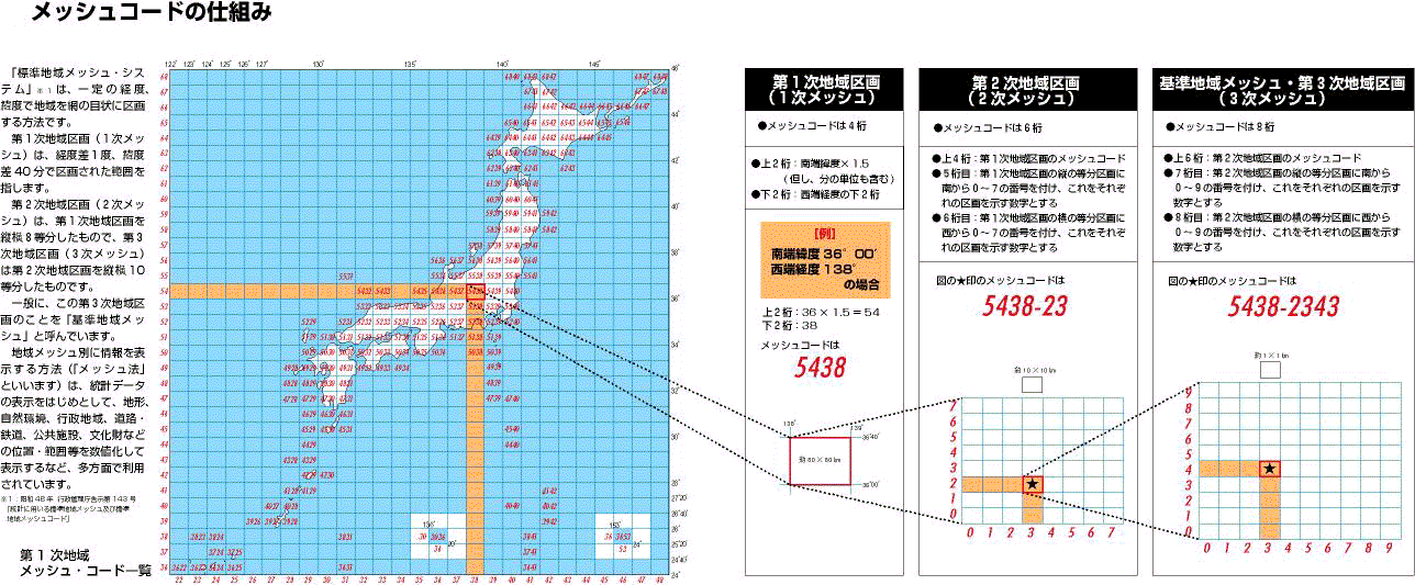
The "Grid Square System" is based
on the Administrative Management Agency's
Announcement No. 143 of July 12, 1973: "The
Grid Square System and Grid Codes for Statistical
Use" which uses lines of longitude and
latitude to section an area into a grid.
The first area section is based on a difference
of one degree of longitude and forty minutes
of latitude. The second area section divides
the first into 8 parts of equal length and
breadth and the third area section divides
the second into 10 equal parts. Generally,
it is the third section that is referred
to as the "Standard Area Grid"
or "3rd grid." A grid five times
the size of the 3rd grid can also be used
depending on the character of the target
data.
"The Grid Square System" [*1] uses
longitude and latitude to section an area
into a grid.
The first area section (1st grid) is based
on a difference of one degree of longitude
and 40 minutes of latitude.
The second area section (2nd grid) divides
the first into 8 parts of equal length and
breadth. The third (3rd grid) divides the
second by 10 equally.
Generally, the third area section is called
the "Standard Area Grid"
The method of using grids to show information
(called the grid approach) is a good way
of exhibiting statistical data, topography,
features of the natural environment, administrative
districts, roads, railways, public facilities,
the location and scale of cultural assets
and so forth in quantitative form. It is
widely used.
[*1] Administrative Management Agency Announcement
No.143, "The Grid Square System and
Grid Codes for Statistical Use"
| Grid Units |
Scope and Size |
|---|---|
| The first area section (1st grid)) |
Longitudinal difference 1 degree, latitudinal difference 40 minutes Corresponds to a 1:200,000 scale topographical map About 80 X 80Km* |
| The second area section (2nd grid) |
Longitudinal difference 7 minutes 30 seconds, latitudinal difference 5 minutes Corresponds to a 1: 25,000 scale topographical map About 10 X 10km |
| The third area section (3rd grid, Standard Area Grid) |
Longitudinal difference 45 seconds, latitudinal difference 30 seconds. Corresponds to each of ten equal divisions of the 1:25,000scale topographical map About 1 X 1km |
| Multiple - 5 Area Grid |
Longitudinal difference 3 minutes 45 seconds, latitudinal difference 2 minutes 30 seconds. Corresponds to each of four equal divisions of the 1:25,000 scale topographical map. About 5 X 5km |
| Prefectures, Towns, Villages |
No. of Cities, Wards(*1) |
1st Area section |
2nd Area Section |
3rd Area Grid |
| All Japan |
3,383 |
174 |
4,866 |
386,555 |
| 01. Hokkaido 02. Aomori 03. Iwate 04. Miyagi 05. Akita 06. Yamagata 07. Fukushima 08. Ibaraki 09. Tochigi 10. Gunma 11. Saitama 12. Chiba 13. Tokyo 14. Kanagawa 15. Niigata 16. Toyama 17. Ishikawa 18. Fukui 19. Yamanashi 20. Nagano 21. Gifu 22. Shizuoka 23. Aichi 24. Mie 25. Shiga 26. Kyoto 27. Osaka 28. Hyogo 29. Nara 30. Wakayama 31. Tottori 32. Shimane 33. Okayama 34. Hiroshima 35. Yamaguchi 36. Tokushima 37. Kagawa 38. Ehime 39. Kochi 40. Fukuoka 41. Saga 42. Nagasaki 43. Kumamoto 44. Oita 45. Miyazaki 46. Kagoshima 47. Okinawa |
226(*2) 67 62 75 69 44 90 88 49 70 92 80 65 58 112 35 41 35 64 121 99 75 103 69 50 54 67 99 47 50 39 59 78 93 56 50 43 70 53 109 49 79 98 58 44 96 53 |
39 8 7 5 6 6 6 5 4 5 4 5 21 4 7 4 5 4 3 8 6 7 6 4 4 5 2 6 5 4 4 9 6 4 7 4 2 5 6 5 4 10 5 5 5 18 15 |
1,127 152 192 111 156 123 175 89 85 91 54 79 85 46 192 63 77 71 65 175 137 115 77 94 56 76 36 122 52 74 61 115 99 117 107 61 48 111 109 87 42 130 110 95 100 204 110 |
91,385 10,411 15,966 7,855 12,164 9,583 13,848 6,088 6,465 6,470 3,853 5,285 2,669 2,581 13,038 4,376 4,488 4,417 4,494 13,548 10,596 7,839 5,274 6,073 3,541 4,781 2,030 8,540 3,712 4,854 3,624 6,880 7,192 8,734 6,584 4,192 2,214 6,239 7,147 5,121 2,526 5,477 7,519 6,396 7,547 9,825 2,874 |